Malheur Maar
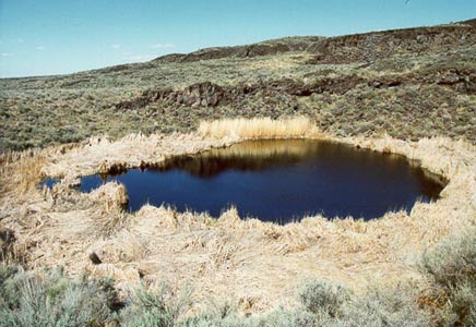
Malheur Maar is one of the most significant desert lakes on the continent, and is especially usefull for studying past climates. Malheur Maar and Dry Maar both fit the exact description of a true maar, meaning that no magma surfaced during an eruption. The water in Malheur Maar is about 6 feet deep, and there are about 50 feet of sediments underneath the water which fill up half of the original maar floor. Malheur Maar has contained water for the last 7,000 years. Polen, plant debris, and layers of tephra accumulate rapidly in the lake, which is located at the boundary between the sagebrush and the desert shrub communities.
Directions:
Back on the main road from the twin maars, travel straight, ignoring the many dead end side roads until you reach a wide curve with a parking area on the north side of the road. The parking area is next to Dry Maar, and to get to Malheur Maar you must take the small hiking trail to the north for about 300 feet.
|