|
|
|
|
|
|
|
|
|||||||||||
|
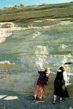
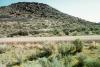
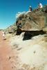
Wrights Point started out as a simple meandering stream, with layers upon layers of sediments on the stream bed. A lava flow in the Pliacine age ended up flowing down the stream valley capping all of the stream sediments with a layer of basalt. Over time erosion has taken its toll on the entire area around Wrights Point, but remarkably, the basalt-capped river valley was more resistant to erosion that the land around it, and what is left today is almost and inverse mold of that original river valley. Wrights Point sticks up the surrounding landscape about 200 feet, 200 feet wide, and is more than 10 miles long, flattening out as is reaches the drainage basin for Malheur Lake. There are 2 good places to stop when traveling up (or down) the southern side of Wrights Point. At the bottom of the hill, where the stream deposits are located, what you find is a large amount of tuffacious mudstone and siltstone, pumice, sands and gravel, and diatomite (above picture). Looking at the wall of sediments you can see cross-bedding, where the current has brought in sediments and formed dune-like structures. Another thing to notice is that there are many different sediment sizes deposited in different layers, showing how the velocity of the river was fluctuating, and also giving hints at the rate of flow in the river at different perioids of time. The 2nd place of interest is near the top of the southern side of Wrights Point. The top layer of sediments here have been baked by the basalt that flowed above it, and there is a visible alteration from the heat by the lava. Because of the different resistanaces to erosion, stream sediments have eroded quicker that the basalt that caps it, as in the bottom picture on the right. Directions: From Burns, Oregon, travel south on HW205 for about 10 miles. Driving south it will look like a mesa, and it is very hard to miss (HW205 crosses over Wrights Point itself). The best places to stop and get a good look are both on the southern side, at the top where the basalt cap is located, and at the bottom where there is a good outcrop of stream sediments. |
||||||||||||
|